Where's Dave and Jody?

Monday, August 21, 2006

Nebesna Road (North Entrance into Wrangell St. Elias National Park)

The 42-mile Nebesna Road leads into the northern side of Wrangell St. Elias National Park. It crosses three streams without the use of bridges. We have encountered a lot of rain recently so we didn’t know how far our van, Hans, would make it - but we thought we would give it a shot.

Some Scenery Along the Road

This road is home to a hardy group of locals since before the area became Wrangell St. Elias National Park. They have united to protect the area and their way of life. They had posted this neat sign near the Park Service Visitor Center.

We crossed the first stream without a problem. It consisted of a trickle of water over the roadbed. The second stream at mile 30.5 was a different story. It would have been a 50-50 shot if we made it or not. The water wasn’t too deep but it had cut out a pretty good channel and there was more rain in the forecast. We decided not to chance it and instead stayed at a nice FREE, Park Service campground just down the road. We had the place to ourselves. The rain ceased enough for us to have a nice campfire and to explore the nearby lake with the dogs.

Stream Crossing We Didn’t Chance

By the time we woke in the morning the temperature had dropped to 37 degrees. We packed up and as we were heading out the temperature continued to drop till the rain became a STEADY snow storm. The big, fluffy flakes were actually sticking to the ground. And this was August 21 – a bit early, even for Alaska.

This is a shot of when the snow first started falling. It had accumulated a lot more than this by the time we got back to the main highway.

McCarthy and Kennecott (Wrangell St. Elias National Park)

From Valdez, we headed into Wrangell St. Elias National Park via the 
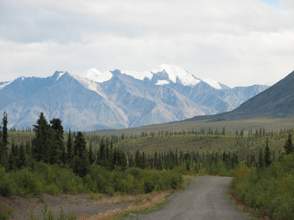
Edgerton Highway. This 93-mile highway leads past the town of 
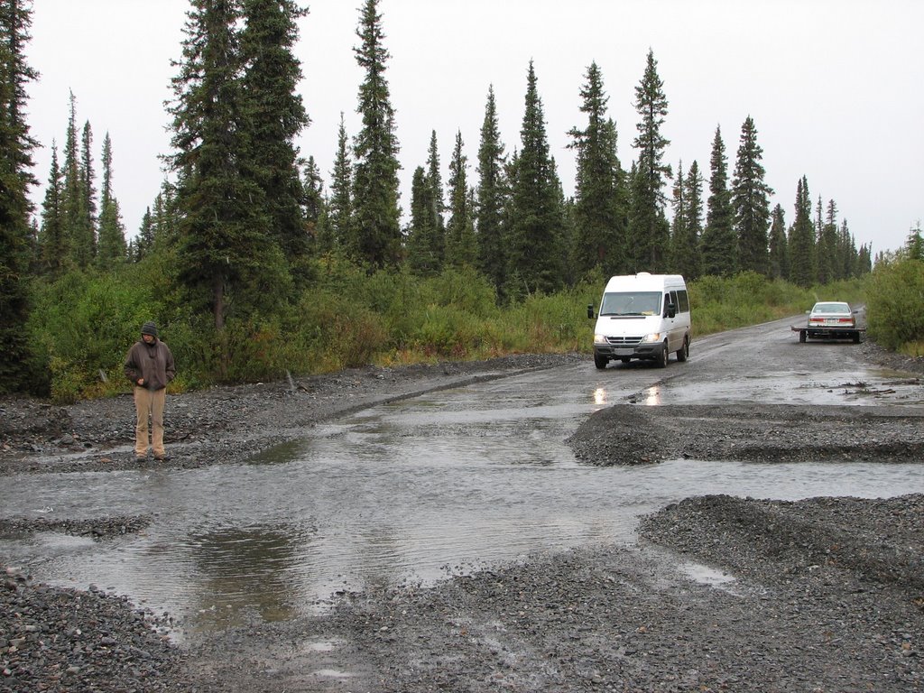
Chitina, where Alaskan residents are allowed to dip net for salmon along the river. After Chitina, the road becomes gravel and the real adventure starts. The highway follows an old railroad grade. The guide books say to watch out for old railroad spikes in the roadway.

Old Railroad Next To Road

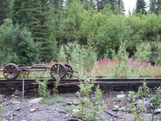
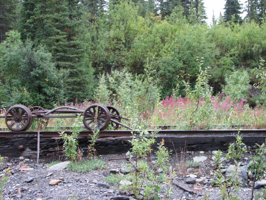
The railroad was put in to access the cooper mine in Kennecott, six miles farther than you can drive today. Seems some prospectors found the mother load of cooper ore in the vicinity. While they began to develop the mine and all the associated necessities, the railroad was being built along the Cooper River from Cordova on the sea coast.

Copper River

This photo is of a crazy railroad bridge on the Edgerton Highway, over the Gilahina River. We later found out this bridge only took 9 days to complete.

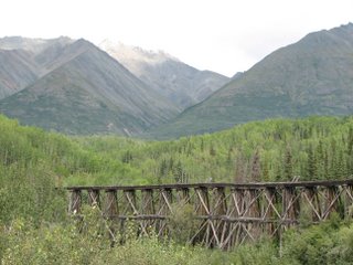
Another Crazy Bridge Along Road

The present day road ends one mile away from the town of McCarthy. McCarthy is about five miles away from Kennecott. In order to reach McCarthy you must walk the mile into town. This requires you to cross two foot bridges.

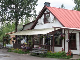
McCarthy is a fun little town made up of many people our age. Most of them were guides who take people into the wilderness via glacier hikes, rafting or backcountry hiking trips. We had a great time meeting new people and drinking some beer in the local saloon.

Lodge and Saloon in McCarthy

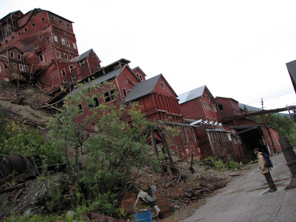
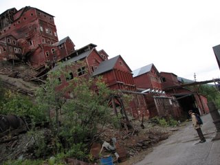
From McCarthy, you can hike the remaining 5 miles to Kennecott. Kennecott is where the actual mining operation was located. Now it is home to just a few year round locals. The National Park Service bought a bunch of the buildings and is in the process of restoring many of them. We got there too late to go on a guided tour. Instead we ran into a guy we met at the bar and he gave us a personal guided tour inside many of the buildings that are closed to the public.

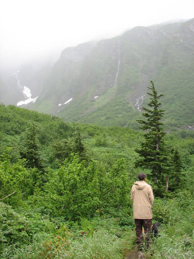
Dave Walking the Road to Kennecott

It was very interesting to see all the work that went into creating this operation. The mine was open 1911 – 1938 and some of the purest copper ever mined came out of it. Everything about Kennecott was massive. One building is 14 stories tall. They had their own power plant, hospital, school, saw mill and bunkhouses. Today most of the buildings are still standing, while others, like the saw mill, were a pile of rubble.

Concentration Mill Building (14 Stories Tall)

Restoration Evidence

Everywhere you walked there was evidence of the mining operation. The locals call this accumulated stuff “Kenne-crap.” It was all over, shovels sticking out of the earth over here. Old ore buckets over there. Seems the old timers just threw their garbage near the nearby glacier. As a result there is a big pile of rotted out metal containers and other misc. stuff. People walk down there and pick through it. Weird.

Example of Kennecrap

After the tour we caught a ride down in the back of a guide’s pickup. As we sat in the back with the wind in our hair looking out at the Wrangell Mountains and the Root Glacier, we wondered “Can life get any better?” We will be back to McCarthy/Kennecott. Let’s hope it doesn’t become any more commercialized because it is just wonderful as it is.

Wednesday, August 16, 2006

Valdez

From the Glenn Highway we jumped back on the Richardson Highway and headed south to Valdez. The last 40 or so miles outside of Valdez are breathtaking beautiful. There were waterfalls and glaciers around every bend in the road.

Worthington Glacier

Bridal Veil Falls

Horsetail Falls

Now we are sitting in the Valdez library.

We will leave here in a couple of hours and head back north. This time we will take the spur road into Wrangell Saint Elias National Park.

Glenn Highway

We took the Glenn Highway east from Anchorage and were treated to many sights of glaciers. Here are a few of them.


Whitter

From Seward we traveled back north towards Anchorage. We took the spur road to Whitter. It was a fun drive, as you must go through a 2.5 mile tunnel to access the town. The rain prevailed throughout the day and night but it didn’t deter us from doing a short hike to a scenic overlook.

From Whitter we went back to Anchorage. We again met up with Mary and Shane, stayed at their house and ran all sorts of errands. We even had a vet appointment to get the dogs health certificates for the ferry.

Exit Glacier Photos


Seward, Exit Glacier, Boat Trip and Sea Life Center

From Nikiski, we again traveled through the Kenai Peninsula. We backtracked somewhat back across the Kenai Peninsula to get to Seward. Once again we saw salmon spawning in almost every waterway.

We were lucky enough to find free camping on Exit Glacier Road (I will post Exit Glacier photos in a new blog. I think I am wrighing this one down.). We camped just off a huge gravel bar on the Resurrection River. It was a beautiful spot. Both dave and sprout took advantage of being near the water for an icy dip.

Camping Spot on Resurrection River

Dave and Sprout Swimming

The next day we took a boat trip into Resurrection Bay. For six hours we were on the water and were lucky enough to see all kinds of wildlife. Miraculously I didn’t throw up during the trip. (I had done this same trip last year when my family came to visit. Unfortunately, I ended up throwing up before the trip was over!!) Although the weather was rather cloudy we still had an amazing time. Here are a few of the better photos:

Rocky Spires

Stellar Sea Lions

Black Bear

Aialik Glacier

Orca Whales (We saw over 40 of them)

Puffins


Before we left Seward, we headed the Sea Life Center. This educational and research facility was built by Exxon after the 1989 oil spill in Prince William Sound. We were able to see most of the same wildlife from the day before but much closer. In addition to huge aquariums, they have touch pools where you can touch all sorts of marine creatures. It was a good way to finish our stay in Seward.

A Type of Sea Star

Kids with a Sea Lion

King Crabs

Dave and a Harbor Seal

Fishy Friend

Homer to Nikiski

While traveling north from Homer, we read about the community of Anchor Point. Supposedly this is the farthest west you can drive on the North American road system. You can get to spots further west, but you need to take your vehicle by boat or air. We have already traveled to the farthest north (Prudhoe Bay outside Deadhorse) so we thought we should take advantage and capture the moment with a photo.

After we left Anchor Point, we traveled north to the small community of Nikiski (Nik-is-key). While we were at the Talkeetna Bluegrass Festival, a girl told Dave about the beaches there. She said we shouldn’t miss them. So we took her advice and went up to see them. Unfortunately, the sun was not shinning, so we didn’t spend too much time on the beach. It was uncanny how much it looked like the Upper Peninsula of Michigan. The dogs had a great time exploring.

Thursday, August 10, 2006

Kenai Peninsula

After Anchorage we headed south to the Kenai Peninisula. We saw sights like this along the way.

All along the Kenai Peninsula, we saw the same combat fishing everywhere we looked. Here is a view of it in the community of Kenai. This photo was taken where the Kenai River, a major drainage, dumps into Cook Inlet.

These posters were hanging in the visitor center. Apparently there are a lot of people who get fish hooks and weights in their eyes.

We stopped at Funny River Recreation Area to see our friends Kathy and Dusty. They were campground hosts just north of Coldfoot for the first couple of seasons I worked there. They were back at Funny River for their second summer. Originally from Michigan, it is always fun to chat with them. They gave us some freshly caught salmon. We feasted on it last night. It was delicious.

Tonight we find ourselves in Homer, the end of the road. To get any further south, we will have to travel back north. We have spent the day checking out the sights around town and along a road that follows Kachemak Bay. We hope to visit the Home Brewing Company and Salty Dawg Saloon before the night is over.

Salty Dawg Saloon

Kachemak Bay Views. There are people who have this as the view out of their front windows!!

Boats, boats and more boats everywhere you look. Homer really is a fishing community.

Anchorage

When we finally made it to Anchorage, we settled in at Mary and Shane’s house. We had a great time catching up with them and sitting by their fire pit eating BBQ. It was a nice relaxed couple of days.

A couple of their friends stopped by each night and we drank beer outside till the sun finally went partly down near 11:00 each night.

While we were in Anchorage, we went downtown to Ship Creek and watched the people fishing for salmon. They call it combat fishing because there are so many people fishing so closely together. Makes you wonder how it can be called fun. We saw a fair amount of fish in the water but even more lines getting tied together.